
Flood Watch National Weather Service Burlington VT 324 AM EDT Mon Jul 10 2023
 Widespread, heavy rainfall capable of producing considerable to catastrophic flooding is beginning to unfold. Road washouts are ongoing, and are expected to increase in extent and severity over the course of the day.
Northern Franklin-Eastern Clinton-Southern Franklin-Western
Clinton-Western Essex-Eastern Essex-Grand Isle-Western Franklin-
Orleans-Essex-Western Chittenden-Lamoille-Caledonia-Washington-Western Addison-Orange-Western Rutland-Eastern Franklin-Eastern Chittenden-Eastern Addison-Eastern Rutland-Western Windsor-Eastern Windsor-Including the cities of Fort Covington, Malone, Champlain,Plattsburgh, Saranac Lake, Tupper Lake, Dannemora, Ellenburg,Lake Placid, Newcomb, Port Henry, Ticonderoga, Alburgh, South Hero, St. Albans, Swanton, Derby, Newport, Island Pond,
Lunenburg, Burlington, Shelburne, Johnson, Stowe, Hardwick, St.
Johnsbury, Montpelier, Waitsfield, Middlebury, Vergennes,
Bradford, Randolph, Fair Haven, Rutland, Enosburg Falls,
Richford, Richmond, Underhill, Bristol, Ripton, East Wallingford,
Killington, Bethel, Ludlow, Springfield, and White River Junction
…FLOOD WATCH REMAINS IN EFFECT THROUGH TUESDAY EVENING…
* WHAT…Flash flooding caused by excessive rainfall.
* WHERE…All of Vermont, and in northern New York, Essex, Clinton,
and Franklin Counties.
* WHEN…Through Tuesday evening.
* IMPACTS…Excessive runoff may result in flooding of rivers,
creeks, streams, and other low-lying and flood-prone locations.
Creeks and streams may rise out of their banks. Flooding may occur
in poor drainage and urban areas. Low-water crossings may be
flooded. Storm drains and ditches may become clogged with debris.
Extensive street flooding and flooding of creeks and rivers are
possible. Area creeks and streams are running high and could flood
with more heavy rain.
* ADDITIONAL DETAILS…
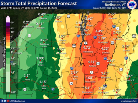
– Widespread rainfall amounts of 2 to 5 inches, with locally
higher amounts of over 7 inches especially near and along the
spine of the Green Mountains. While the heaviest rainfall
rates should abate by Monday evening, widespread area and
river flooding is expected to persist through Tuesday.
PRECAUTIONARY/PREPAREDNESS ACTIONS…
You should monitor later forecasts and be prepared to take action
should Flash Flood Warnings be issued.
Posted: July 10th, 2023 under General News, Northern NY News, Peru/Regional History, Regional NY-VT News, Weather News/History.