
…WINTER STORM WARNING REMAINS IN EFFECT UNTIL 6 AM EDT FRIDAY…
 URGENT – WINTER WEATHER MESSAGE
National Weather Service Burlington VT
231 PM EDT Thu Apr 4 2024
Northern St. Lawrence-Northern Franklin-Southern Franklin-
Western Clinton- Including the cities of Massena, Norfolk, Fort Covington, Malone, Saranac Lake, Tupper Lake, Dannemora, Ellenburg, Lake Placid, and Newcomb.
231 PM EDT Thu Apr 4 2024
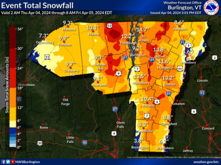
…WINTER STORM WARNING REMAINS IN EFFECT UNTIL 6 AM EDT FRIDAY…
* WHAT…Heavy snow. Additional snow accumulations of 2 to 8
inches for a storm total of 10 to 20 inches, with localized
amounts near 2 feet for the northern and central Greens and
eastern Adirondacks.
* WHERE…Portions of northern New York and central, northern,
eastern, and southern Vermont.
* WHEN…Until 6 AM EDT Friday.
* IMPACTS…Scattered to widespread power outages will continue,
with areas of very difficult travel continuing overnight.
* ADDITIONAL DETAILS…Localized snowfall rates up to 1 inch per
hour will be possible at times tonight.
PRECAUTIONARY/PREPAREDNESS ACTIONS…
If you must travel, keep an extra flashlight, food, and water in
your vehicle in case of an emergency.
Please allow extra time if travel is necessary.
Posted: April 4th, 2024 under Adirondack Region News, Northern NY News, Weather News/History.